

WAYS OF MAPPING / PICTURING A PLACE
A country
in miniature.
Mountains you can recognize. Lakes you can follow. How does a country become small enough to hold—and clear enough to read?
Unfold the atlas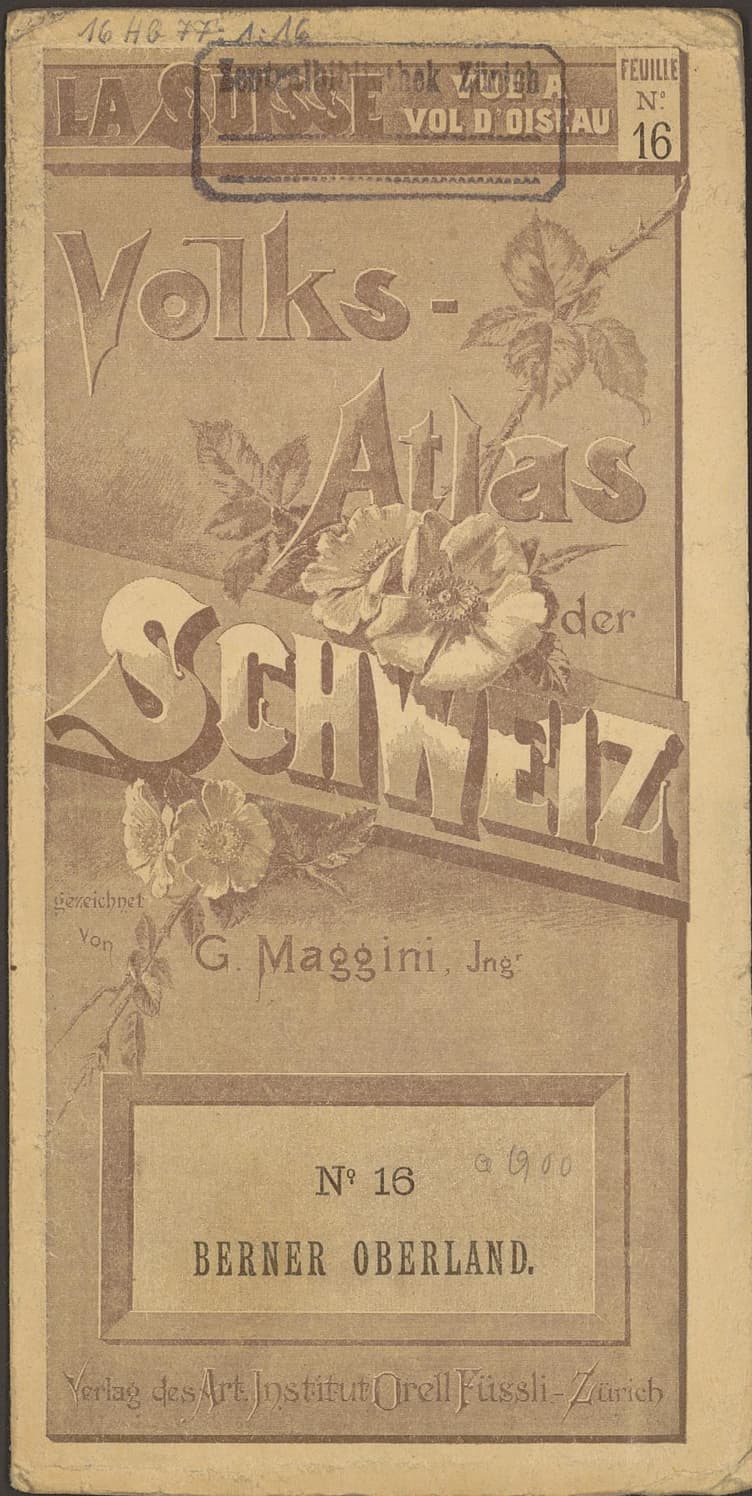
Zentralbibliothek Zürich / e-raraSource & rights +
Berner Oberland — leaf 16. Leaf 16, Berner Oberland. Printed map and border retained; scanner background and color target cropped away. Original colors and orientation preserved.
Zentralbibliothek Zürich identifies this atlas on e-rara with the Public Domain Mark. Source: Giovanni Maggini, Volks-Atlas der Schweiz, Orell Füssli, [1894–1906], Zentralbibliothek Zürich, 16 Hb 77: 1, doi:10.3931/e-rara-28040.
The catalog dates the atlas [1894–1906]. This range is not a single survey date for all its leaves.
Open source record ↗Open uncropped archive scan ↗
A map can invite recognition before measurement.
Before reading a single name, you can begin to understand this landscape. Pale water opens between dark slopes. White peaks gather into a mountain world. A cluster of small marks suggests a town. The drawing offers places to look before it asks you to decode its details.
Our specimen is Giovanni Maggini’s Volks-Atlas der Schweiz, also titled La Suisse vue à vol d’oiseau: Switzerland seen from a bird’s-eye view. The Zentralbibliothek Zürich catalog describes an atlas of 28 colored sheets, published by Orell Füssli, and dates it [1894–1906]. Here we read three leaves, rather than treating one picture as the whole country.
Look closely at the mountains. You see their sides as well as their arrangement across the page. This gives the terrain a bodily presence: the ridges seem to rise, the valleys seem to recede. A useful first question is what that way of drawing helps you understand. A second is what it cannot establish on its own.
Three leaves. Three invitations to look.
Move from the Bernese Alps to Zürich, then to Lake Lucerne. Each detail brings a different part of the map’s language forward. Return to the whole sheet whenever the enlarged view begins to feel like a world of its own.
THE DETAIL IN ITS SHEET
The mountain turns toward you.
Dark faces and white summits make the mountains stand out. Fine names cross the drawn slopes. Find Jungfrau and trace the contrast between its dark face and the surrounding white areas.
Does the shape help you recognize a mountain, measure it, or both? What would you need to check?
Enlarge the selected map view
Zentralbibliothek Zürich / e-raraSource & rights +
Berner Oberland — leaf 16. Leaf 16, Berner Oberland. Printed map and border retained; scanner background and color target cropped away. Original colors and orientation preserved.
Zentralbibliothek Zürich identifies this atlas on e-rara with the Public Domain Mark. Source: Giovanni Maggini, Volks-Atlas der Schweiz, Orell Füssli, [1894–1906], Zentralbibliothek Zürich, 16 Hb 77: 1, doi:10.3931/e-rara-28040.
The catalog dates the atlas [1894–1906]. This range is not a single survey date for all its leaves.
Open source record ↗Open uncropped archive scan ↗Berner Oberland / leaf 16
Dark faces and white summits make the mountains stand out. Fine names cross the drawn slopes. Find Jungfrau and trace the contrast between its dark face and the surrounding white areas.
Does the shape help you recognize a mountain, measure it, or both? What would you need to check?
Open the uncropped sheet ↗Zürich / leaf 6
The bold ZÜRICH label sits beside a dense patch of small building marks. Lines approach from several directions while the lake opens below. Words, texture and connections work together to make the city prominent.
Which catches your eye first: the name, the drawn city, or the lines leading into it?
Open the uncropped sheet ↗
Lake Lucerne / leaf 11
Pale water threads between heavily shaded ridges. The lake’s branching shape stays easy to follow even when the surrounding hills are crowded with marks and names.
Follow the water without reading its labels. Then read the names. How does the second pass change your picture?
Open the uncropped sheet ↗
In the Alpine detail, a summit has a name, a number and a drawn face. These marks do different work. The name identifies it; the number adds a quantitative statement; the shaded face makes the landform visible. The number deserves its own source check before being used as a current elevation. The drawing’s apparent steepness cannot substitute for a measured slope.
At Zürich, attention gathers differently. A large label and a concentration of building marks pull the city forward. Approaching lines place it in a wider system of connections. You can notice that structure without assuming every small building mark is an individually surveyed footprint.
At Lake Lucerne, the comparatively quiet water becomes a path for the eye. Trace it around the ridges, then look for the place names along its edge. The map lets the lake act as both a shape and a setting for named places. Its visual clarity comes partly from the crowded texture around it.
A picture can make a place easier to recognize without making every distance easier to measure.
The country continues beyond the edge.
A single leaf gives us a region. The title on its cover gives that region a national setting. The atlas is therefore doing something a stand-alone landscape picture cannot: it offers a sequence through which a reader can assemble a larger world.
The whole country.
One leaf at a time.
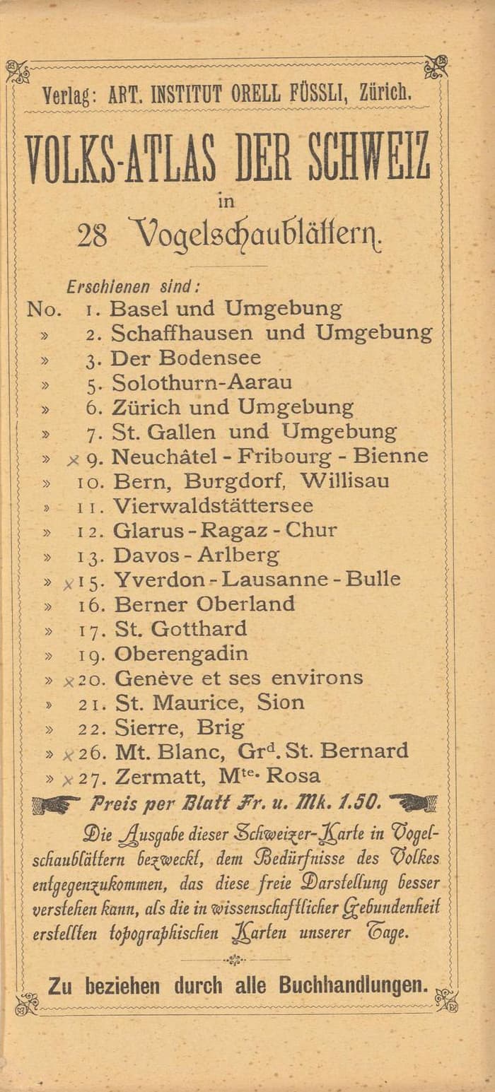
The cover names Switzerland; its lower panel names Berner Oberland. The publisher’s list names other parts of the country a reader could collect.
Below the list, the publisher presents the freer pictorial treatment as easier for a general audience to understand than the strictly constructed topographic maps of the day.
That is the publisher’s argument, paraphrased from the printed German. It tells us how the atlas was promoted; it does not prove how every reader understood it.
Read the publisher’s original list
Zentralbibliothek Zürich / e-raraSource & rights +
Berner Oberland — folded cover. Folded cover for leaf 16. Its national title and regional leaf name operate at different scales.
Zentralbibliothek Zürich identifies this atlas on e-rara with the Public Domain Mark. Source: Giovanni Maggini, Volks-Atlas der Schweiz, Orell Füssli, [1894–1906], Zentralbibliothek Zürich, 16 Hb 77: 1, doi:10.3931/e-rara-28040.
The catalog dates the atlas [1894–1906]. This range is not a single survey date for all its leaves.
Open source record ↗Open uncropped archive scan ↗
Zentralbibliothek Zürich / e-raraSource & rights +
List of available atlas leaves — reverse of leaf 11. Publisher’s list on the reverse of leaf 11. This is a list of available leaves, not a geographic coverage diagram or a new inventory of the archive.
Zentralbibliothek Zürich identifies this atlas on e-rara with the Public Domain Mark. Source: Giovanni Maggini, Volks-Atlas der Schweiz, Orell Füssli, [1894–1906], Zentralbibliothek Zürich, 16 Hb 77: 1, doi:10.3931/e-rara-28040.
The catalog dates the atlas [1894–1906]. This range is not a single survey date for all its leaves.
Open source record ↗Open uncropped archive scan ↗
The folds matter. This is a landscape prepared to close, travel and open again. The catalog records sheets that fold to approximately 21 by 11 centimeters. An atlas can make a country manageable through its physical format as well as through the marks on its maps.
The original reverse of the Lucerne leaf also carries advertisements. The country on the page belonged to an object being printed, distributed and sold. Keeping the cover and publisher’s list nearby helps us see that object, instead of receiving the landscape as an anonymous picture.
Ask what the picture makes easy.
“Accurate or inaccurate?” is too broad a starting question for everything we ask of a map. Begin with a task. Can you identify a named mountain? Follow the lake? Notice a city’s connections? Estimate a distance? Each task requires different evidence.
These sheets can support a close reading of how a landscape is pictured. They do not, by themselves, establish today’s glacier margins, building locations or railway services. Their paper colors are not a modern land-cover classification. Their date range describes the cataloged publication, not one simultaneous observation of Switzerland.
The same distinction runs through One Railway, Three Maps. A representation preserves some relationships and changes others. Here the question widens from a railway to a country: which features let a reader carry an idea of a place away from the page?
Remember a place. Then check the sheet.
Choose one leaf and look for a few moments. Turn away and name the three things you remember. Return to the whole sheet. Were those things made prominent by size, contrast, position or wording? What did you overlook?
Sources & method
Maggini, G. ([1894–1906]). Volks-Atlas der Schweiz in 28 Vogelschaublättern = La Suisse vue à vol d’oiseau [Atlas]. Orell Füssli. Zentralbibliothek Zürich, 16 Hb 77: 1. https://doi.org/10.3931/e-rara-28040
Map leaves 6 (Zürich and surroundings), 11 (Vierwaldstättersee) and 16 (Berner Oberland), with the cover of leaf 16 and the publisher’s list on the reverse of leaf 11. The archive’s Public Domain Mark applies to this source; its bibliographic record and original scans remain linked beside the images.
Cartologium prepared local display copies from the archive’s IIIF images. Crops remove scanner surroundings and, for the Lucerne map, an adjacent advertising flap. Source colors, names and orientation are preserved. The whole-sheet mode retains the printed map and its border. The close-reading windows and copper locator outlines are editorial additions in image pixels; no geographic registration or uniform screen distance scale is claimed.
The readings describe visible marks and distinguish our interpretation from the publisher’s stated pitch. The selected leaves are a starting point for reading the atlas, not a claim of complete coverage of Switzerland. The social illustration is an original, schematic Cartologium composition.