

Return to Map Specimen Database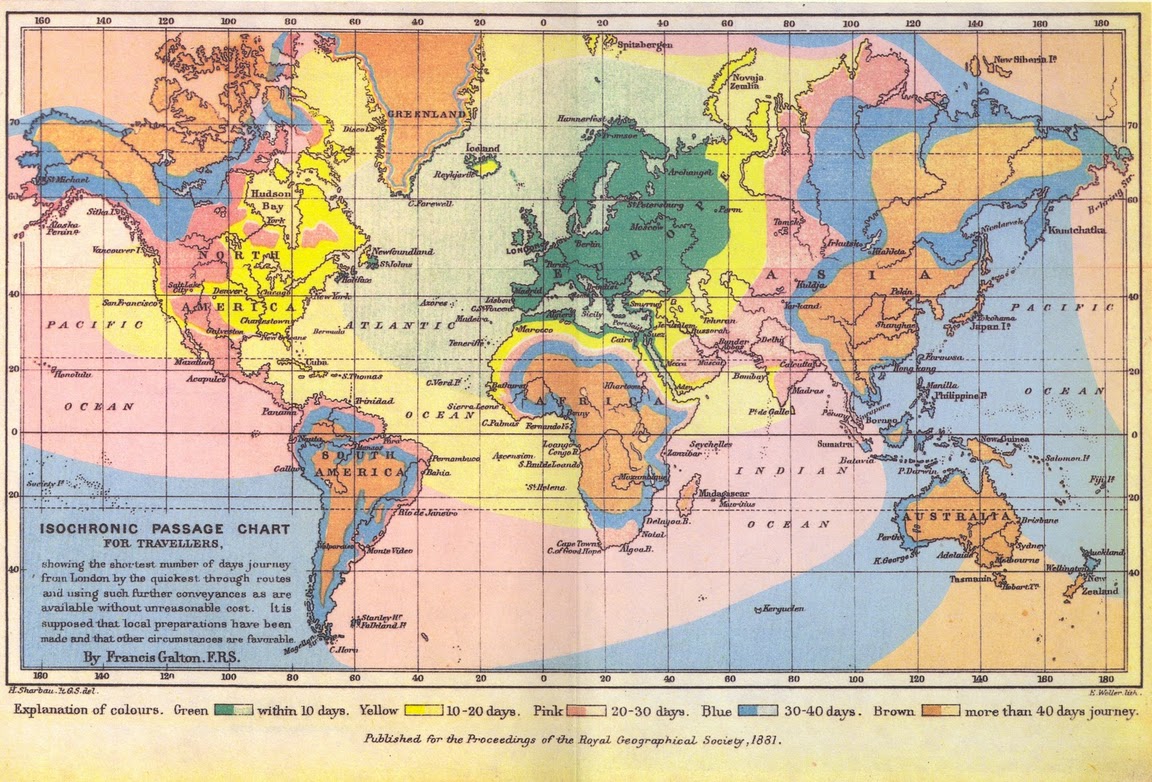
Era: Thematic & Scientific Revolution·Historical mapmaker: Francis Galton·Year: 1881·Image reuse: Public domain
Galton’s Isochronic Passage Chart from London (1881)
"The first map measuring global distance in travel days rather than physical miles"
Published in 1881, Galton colored the globe according to travel time from London: green (< 10 days), yellow (10–20 days), pink (20–30 days), light blue (30–40 days), and brown (> 40 days).
Interactive Specimen Pan & ZoomAccession: RGS Archive / PRGS Vol. 3 No. 11
Orientation: North-Up
450 × 280 mm
Francis Galton; via Wikimedia Commons·Reproduction·Image source record
ZOOM: 100%Repository Archive
Notable Cartographic Signatures
- Concentric colored isochronic bands radiating from London
- Shows how railways compressed continental travel (e.g. crossing the US in 10 days via transcontinental rail)
- Visualized how inland Africa and central Australia remained temporally isolated
Image credit and reuse
Galton’s Isochronic Passage Chart from London (1881)
Francis Galton; via Wikimedia Commons
Public domain under the individual source record. Metadata added; image pixels unchanged. Display crop may vary by viewport. Retain source credit and terms. Historical mapmaking context is separate from this image reproduction.
The Rhetorical & Ideological Argument
"Steamships and railways have compressed the globe: time is the true human metric of distance, and London is the temporal epicenter of global reach."
Explicit Features
- Concentric colored isochronic bands radiating from London
- Shows how railways compressed continental travel (e.g. crossing the US in 10 days via transcontinental rail)
- Visualized how inland Africa and central Australia remained temporally isolated
Intentional Omissions
- Local pedestrian travel times away from railway and port nodes
Physical Specimen & Geodesy
Projection:
Mercator Cylindrical Projection with Thematic Isochrone Bands
Orientation Axis:
North-Up
Physical Medium:
Color lithograph on paper
Original Physical Dimensions:
450 × 280 mm
Custodial Repository:
Royal Geographical Society, London / Library of Congress
Accession: RGS Archive / PRGS Vol. 3 No. 11
Interdisciplinary Context & Connections
Interdisciplinary DomainORIGINATES
Isochrone Manifold Workbenches
Differential TopologyCOMPUTES
Cost-Surface Distance Geometry
Academic Provenance: Galton, F. (1881)