

WAYS OF MAPPING / THE BUILT WORLD
An insurance
map at
street level.
A wall, a roof, a working day. Read the city through the things a fire insurance map needed to know.
Look inside the sheetSanborn-Perris · Library of CongressSource & rights +
Phoenix, June 1893 — sheet 3. Library of Congress, Geography and Map Division, Sanborn Maps Collection.
The Library of Congress identifies its online Sanborn Maps Collection as public domain and free to use and reuse. Source credit: Library of Congress, Geography and Map Division, Sanborn Maps Collection.
Open source record ↗Open full-resolution scan ↗
The city becomes a set of questions.
A railway map helps us follow a connection. A pictorial map can make a landmark loom over its neighbors. This map brings our attention down to individual walls. A small structure behind a larger building, a change in construction, or a note about a water supply can become worth recording.
Sanborn maps were made to help fire insurance agents assess property hazards. Their outlines, colors and symbols record construction and other details relevant to that work. The purpose helps explain why an ordinary building may receive more technical attention here than a monument does on another kind of map.
Our specimen is Phoenix in June 1893. The Library of Congress catalogs an edition of fifteen sheets; its title page names the Sanborn-Perris Map Co. We will read sheet 3 and use the original key on sheet 1. The date belongs to the publication. It does not tell us that every mark was observed on the same day.
A building has more than an outline.
WHERE YOU ARE ON THE SHEET
The outlined window is added by Cartologium. North points left in the original sheet.
Read this detail at a larger size
A footprint with an operating note
The Phoenix Ice Factory note records wood fuel, four employees, water from a well and city water. The drawing names freezing tanks and an engine room.
What can the written note tell you that the outline alone cannot?
Sanborn-Perris · Library of CongressSource & rights +
Phoenix, June 1893 — sheet 3. Library of Congress, Geography and Map Division, Sanborn Maps Collection.
The Library of Congress identifies its online Sanborn Maps Collection as public domain and free to use and reuse. Source credit: Library of Congress, Geography and Map Division, Sanborn Maps Collection.
Open source record ↗Open full-resolution scan ↗Ice factory
The Phoenix Ice Factory note records wood fuel, four employees, water from a well and city water. The drawing names freezing tanks and an engine room.
Houses
Along East Washington, pink and yellow portions meet within individual footprints. Small letters, numbers and roof marks add information to the colored shapes.
Hotel & stable
The lower part of the sheet labels Mills House and a livery stable. A large crossed rectangle appears beside the word Stable; compare it with the stable sign in the key.
Begin with the ice factory. The building drawing and the adjacent writing cooperate. One gives shape and position; the other describes aspects of operation. The factory’s name is only the beginning of the record. Fuel, staffing and water appear in the same small space.
Read those statements as the map’s account. A note that water came from a well and the city is evidence of what this sheet records, rather than an independent inspection of the system. The map provides a precise starting point for another question: which records could help us check how that supply worked?
Now choose Houses. Follow a pink area into an attached yellow portion. Instead of treating each footprint as a single colored object, look for the joins. The map can distinguish parts within one structure. The surrounding letters, roof marks and numbers then ask for another layer of reading.
Finally, look at the hotel and stable. The large crossed rectangle is a useful test: can you find the corresponding sign in the key? A repeated mark becomes readable when it has a declared meaning. Without that key, a confident guess may still be wrong.
The question behind the map decides which details come forward.
Let the old sheet explain its own language.
In this edition, yellow indicates frame construction and red indicates brick. Brown indicates adobe. Those distinctions come from the key printed with the Phoenix maps. The scans preserve variation in the paper and ink, so a color name can be more dependable than an exact screen shade.
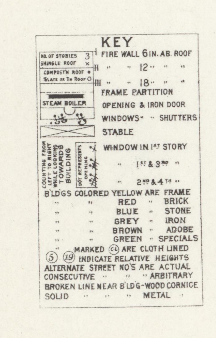
THREE MATERIAL READINGS
- Frame
- The key calls yellow buildings frame. Begin with the small yellow footprints.
- Brick
- The key calls this red; the surviving scan often appears pink. Read the name with the color.
- Adobe
- Brown means adobe in this edition. This key also distinguishes stone and iron.
The swatches are reading aids. The scan preserves the original marks and color variation.
Sanborn-Perris · Library of CongressSource & rights +
Phoenix, June 1893 — original map key. Library of Congress, Geography and Map Division, Sanborn Maps Collection.
The Library of Congress identifies its online Sanborn Maps Collection as public domain and free to use and reuse. Source credit: Library of Congress, Geography and Map Division, Sanborn Maps Collection.
Open source record ↗Open full-resolution scan ↗
The key is also a compact grammar of lines and marks. It distinguishes walls above the roof, openings, windows, roof types and other building features. A color alone does not carry the whole description. Nor does the amount of colored area, by itself, provide an insurance price or a simple ranking of danger.
The Library of Congress cautions that Sanborn symbolization evolved. A convenient general legend can help orient a reader, but the legend issued with an edition is the closer guide to its conventions. Here the blue label means stone. Carrying a different edition’s meaning into this sheet would change the reading.
Color also deserves a second check when you move away from the buildings. On the atlas index, broad colored areas direct the reader to numbered sheets. A yellow patch there is a coverage cue. It does not mean that every building within the patch is made of wood.
A close reading needs an outside.
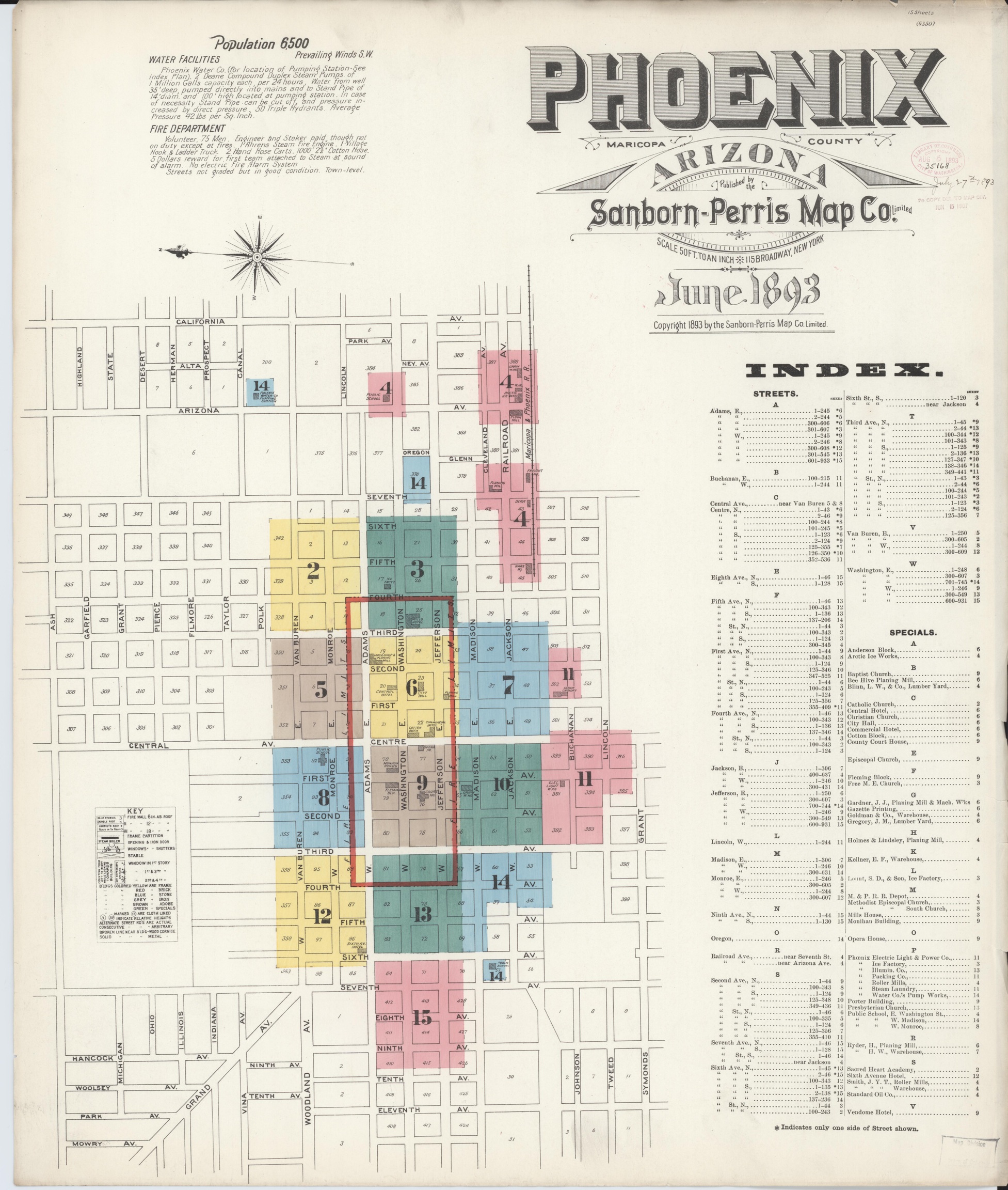
Find the sheet before the street.
On this graphic index, the large 3 sends you to the sheet used in our close reading. Its colored areas organize the atlas.
These colors do a different job from the colors inside building footprints. The same visual language can change meaning within one publication.
Explore the original index ↗Unfold the full title and index sheet
Sanborn-Perris · Library of CongressSource & rights +
Phoenix, June 1893 — title and sheet index. Library of Congress, Geography and Map Division, Sanborn Maps Collection.
The Library of Congress identifies its online Sanborn Maps Collection as public domain and free to use and reuse. Source credit: Library of Congress, Geography and Map Division, Sanborn Maps Collection.
Open source record ↗Open full-resolution scan ↗The close-up makes small writing accessible, but it removes neighbors. Return to Whole sheet and notice what reappears: the compass, adjacent blocks, street names, continuation numbers and scale. North points toward the left. Keeping that orientation visible helps us resist treating the top of every map as north.
The title gives a scale of fifty feet to an inch for the original maps. A scan displayed on a phone or enlarged on a monitor changes physical size. The printed scale remains part of the source, but an inch on your screen is not automatically an inch on the historical sheet.
There is another outside too. A technically detailed building record does not tell us everything about the people inside it. The selected details do not name each resident, describe a household’s routines, or tell us how a place felt. Those questions invite other evidence: directories, photographs, letters and additional maps.
Make a three-line field note.
Choose one detail. Write down one thing the sheet visibly records, one meaning you checked against its key, and one question the sheet leaves open. Return to the whole sheet and add a neighboring feature that helps locate your example.
Return to the detail reader ↑We can now connect this ordinary block to the larger atlas. Landmarks show how prominence is drawn; insurance maps show how a practical purpose changes the detail worth preserving. Both ask us to read the choices between the world and its representation.
Sources and method.
The two full sheets are display copies of Library of Congress scans. Their original orientation, marks and palette are retained. The key is cropped from sheet 1. Detail windows and their locator outlines are added for this reading; they identify positions on the scanned page, not surveyed coordinates on a contemporary basemap.
The Library’s catalog uses the general publisher name Sanborn Map Company; the citation here follows the Sanborn-Perris imprint visible on the title sheet. The edition date is June 1893. We make no claim about which buildings survive or about present-day fire risk.
Sanborn-Perris Map Co. (1893, June). Sanborn fire insurance map from Phoenix, Maricopa County, Arizona [Maps, sheets 1 and 3]. Library of Congress, Geography and Map Division. https://www.loc.gov/item/sanborn00169_003/
Inspect the sourceLibrary of Congress. (n.d.). Introduction to the collection. Sanborn Maps. https://www.loc.gov/collections/sanborn-maps/articles-and-essays/introduction-to-the-collection/
Inspect the sourceLibrary of Congress. (n.d.). About this collection: Sanborn keys, legends, and symbol sheets. Sanborn Maps. https://www.loc.gov/collections/sanborn-maps/about-this-collection/
Inspect the source
Editorial text and original reading aids © Cartologium. Source maps remain public domain. Credit: Library of Congress, Geography and Map Division, Sanborn Maps Collection. Prepared 13 October 2026.